Editors note: I wrote this page when i was about 16 and have kept it alive out of nostalgia. please don't go caving/bushwalking without the appropriate equipment and experience. The info below is given for information but is not sufficient on its own to guarantee your safety etc etc. warp to 21st century website
Well! you appear to have stumbled across the official Blue Waterholes and Cooleman Plain guide. This guide has been created to help people make the most of their trip to this lovely place. If you don't have the faintest idea what or where Blue Waterholes is, then read this!
Cave Creek
The Waterfall
Harris Waterhole
South Branch Streamsink
Gorges
Clarke Gorge
The Second Gorge
Huts and Ruins
Coolamine Homestead
Bill Jones' Hut
Harris Hut Ruin
Spencers Hut Ruin
The Mines
Mt Black Mine
Hancox's Mine
Other Sites of Interest (See map below)
Site 1 - The Blue Waterholes
Site 2 - A Cold Swim
Site 3 - The Dry Gully
Site 5 - Dry Creekbed and Gorges
Site 6 - Limestone on the North Plain
Site 7 - Goodradigbee River
Site 8 - A Funny Thing
Bushwalking in the Area
How to get to Blue Waterholes
A final note
Further Reading
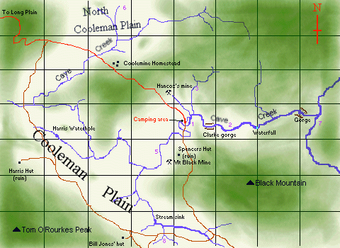
What follows is a description of all the features on the above map. This should give you a better idea of what Blue Waterholes has to offer. Cooleman plain itself is a wonderful place to walk upon. It is large, flat, and mostly treeless. A thich spongy alpine grass covers most of it, and in summer lovely wildflowers grow in abundance. Best of all, you will often have this large expanse all to yourself, even in busy seasons. In these respects it is similar to many other plains in the area. Unlike the others though, Cooleman plain is almost entirely underlain by limestone. This has lent it some interesting features. Because limestone is soluable in rainwater, most streams run underground through caves. Thus, most surface creekbeds are dry in summer. The larger creeks on the plain have also dug some fantastic gorges into the soft rock. Clarke gorge is probably the most interesting of these. A smaller feature is the doline, or sinkhole - a rounded depression in the plain. These appear in profusion across certain areas of the plain, like area 8. A unusual feature seen here and there on the plain is the blockstream. These are easily recognisable as thinish (2-10m wide) streams of boulders running down a slope. These formed from periglacial activity, thousands of years ago when the area was colder. I'm not sure of the details, but it had something to do with frost. ;-) Cooleman plain is a varied landscape. The northern areas have a more remote feel to them. Clumps of trees grow here and there on small hillocks. Water filled dolines make small reedy ponds. No vehicle tracks scar the landscape. Walking here can be a wonderful experience, especially in late autumn, when the weather is gloomy, and everything seems to be going into hibernation. I remember walking across the north plain one dismal morning in the rain...it was mystical...we watched as a pack of brumbies galloped through the mist. The south plain is more travelled, and a bit scruby in it's western parts. I prefer the eastern reaches, where thin streams wind lazily across the plain before they are swallowed up at the streamsink. Dolines are in abundance here. There are also more caves on the south plain (though they're small). Cave Creek drains the Cooleman Plain. During summer, it runs underground for most of it's length, and the dry, silent gorges can be nice walking country . However there is always water rising at the Blue Waterholes near thecamp area. This water has a bluish appearance due to dissolved minerals. It is also very cold. Only madmen swim in it. (but area 2is a good spot) From here on it is a gushing stream which you will have to cross several times if you want to follow it downstream through the gorges. Don't expect to keep your feet dry if you go very far downstream, especially in spring. Cave creek tumbles over a nice waterfall at GR 542564p This is a nice 7m-or-so high waterfall that cave creek tumbles over at GR 542564p. An obvious track leads all the way down cave creek from the camping area to this waterfall, however if you want to continue further downstream to the gorges, you should leave cave creek at this point as it becomes scrubby and difficult to follow. Climb high up on either the north or south bank (I've only ever gone north but south should be OK too) and travel parallel to the creek for a while. You can drop back down to cave creek where it reaches the Goodradigbee river, or when it enters the second gorge. Don't expect it to be very easy going either way. There are virtually no paths. The scenery's good though! A claypan has enabled a fair amount of water to accumulate at this spot on the south plain. It is about the only permanent water on the plain. Don't camp here please as you might pollute it. Camp at the huts instead. There are lots of streamsinks along creeks in this area, this is just one of the more obvious ones. It's exact position varies depending on the flow of the creek ('Seventeen flat creek') that flows into it. For more information regarding sinks and caves, go toThe Blue Waterholes Cave Page
This would have to be the most recognisable feature at Blue Waterholes. It is quite awesome and completely defies description by me. Anyone who's been to Blue Waterholes should have seen it anyway. Anyone who hasn't been aught to go - if only to see Clarke gorge. Try climbing up on either side to get a good view of the countryside and a spooky glimpse down to the creek below.
Very few people visit the second main gorge along Cave creek, mainly because it is much more difficult to get to. You need to do a bit of scrub bashing. (as describedelsewhere). Let me say this: It is well worth the effort.
This is a large complex of huts and sheads built over one hundred years ago by early settlers in the area. It is the only structure of its type (an 1800's colonial homestead) remaining in the park. Please don't camp here as fire is the greatest threat to its continued existance. I have never been to this hut, though I understand that it is a nice place to camp, even though the hut itself is not in very good shape. Please note that you can't park your car anywhere near here as the road is closed. This used to be a wonderful little hut, very well situated in a grassy area off the main plain. It was burnt down in Janurary 1996, by a bunch of guys who were pig shooting and four-wheel driving in the area (both illegal). Looks like they got pissed and built the fire up to such enormous preportions that the entire hut caught alight. As far as I know no charges were pressed. The loss of this precious hut was a great tragedy. Little more than a few sheets of tin, this ruin is easily visable from the road going south from the camp area.
This mine is now little more than a few small piles of tailings, of interest only to geologists probably. The view from here is quite good though, looking out across the plain. The mine isn't hard to find. Make your way to Spencers Hut ruin then head west, and south a bit, through the trees. The piles of dirt are quite visable. I have never been to this mine site. The operations were smaller here than those at Mt Black Mine, so there is probably nothing much left now at all. Most people camp here, where they can set up their tents near to where they park their car. The area can be very crowded during holidays, especially Christmas and Easter. In my opinion you are better off camping elsewhere during these times. On the other hand, late in the season, there is often no-one here at all. You must be careful not to be snowed-in however. Snow has fallen thickly here as early as April (but that is by no means usual). Another nice campsite can be found beneath Black Sallies near the mouth of Clarke Gorge.
This is the central point of the Cooleman Plain. Here, close to the campsite, Cave Creek's waters gush from numerous springs along the creekbed. The NPWS has erected some handy low tables along the bank of the creek, for use by campers.
The area is becoming bereft of firewood however. About 300m downstream of Barbers Cave, the Creek forms a nice, fairly deep waterhole that is good for swimming. A warning though: the water is never even slightly warm. Aproximate GR=534562r Well, there is nothing particularly special about thisarea, but if are in want of a new spot to walk in, that's near the main camping area, I suggest having a wander up this dry creekbed. There are some caves up here but you need a permit to enter them, and theyre small and narrow anyway. A walk up the (usually) dry creekbed of Cave Creek from the campsite is very different from a walk downstream. This is an eerie place - great tall cliffs loom on either side, and you have to walk along a pavement of loose stones, rounded by water which is only present after lots of rain, or in winter/early spring. A walking track runs parallel to the stony creekbed, but it is rather overgrown. I have already spoken of the mystical northern plain. There are lots of minor spots of interest upon it - this is one of them. A small outcrop of limestone containing a couple of small caves - the only ones in the area. The Goodradigbee River runs through some limestone canyons here which are quite marvelous. It takes a while to walk here from the campsite however. They are almost comic, these strange grassy depressions. The appear in profusion in this area, coming in all sizes. I like to lie on my back in one and watch the clouds. A walking track of some sort follows Cave Creek for much of its length. Most people will want to follow this through Clarke Gorge at least. You can also follow one of the vehicle tracks. My advice though, if you just want to wander, is to leave the tracks, and visit sites of interest to you by whatever route you think best. Basic navigation isn't hard on the Cooleman plain, during fine weather, though distances can be deceptive. Be more careful not to get lost when walking through the forest though. All streams shown on theArea Map are fairly obvious and shouldn't be hard to follow (though some dry streams are rather scrubby). For more information about the general hazards and rules to walking in the Kosciusko National Park, please refer to one of the bushwalking books in the bibliography. I don't pretend to be any sort of expert on this area. I'm sure there are lots of people who know more about Blue Waterholes then me. I just happen to love the place enough to want to write a lot about it! If you've found any errors in this guide, or have any comments, then feel free to Email me. Please note that this guide is not really finished yet.
Charles Warner
Geehi Bushwalking Club
Two small notes first:
To find out the whereabouts of caves at Blue Waterholes, and get a nice description of them, go to The Blue Waterholes Cave Page
Throughout the following text, many feature locations are given in the standard 6-digit code, which is used in conjunction with CMA or AUSLIG maps to pinpoint (to 100m) the spot. Most bushwalkers will understand how this code works. If not, then directions can be found written on the maps themselves. It's pretty simple. At the end of each grid number I have added a 'p' or an 'r' to indicate whether the point falls on the (P)eppercorn or (R)ules Point CMA map.
Features of the area
Cooleman Plain
One place these occur is at about GR 518539r. Another is near the west entrance of Clarke gorge.Cave Creek (a.k.a. Cooleman Creek)
Gorges
Mountains
Huts and ruins
Mines
The Camping Area
Other Sites of interest
Bushwalking In the Area
How do you get to Blue Waterholes?
A Final Note
Further Reading
These are some books that I recommend:
Bushwalking in Kosciusko National Park
Snowy Mountains Walks
Guide to Blue Waterholes and the Cooleman Plain /Written by Alex Watt / revised March 1997